Culturalhistory
The cultural-historical value map has been adopted as a policy framework by the municipal council by decision of 18-03-2008. The city council has changed the cultural-historical value map by decision of 29-11-2022. In 2022, a new section will be added to the cultural-historical value map, consisting of Landscapes, Settlements and Elements (line, point and area). The sub-themes Urbanism & Cityscapes, Road & Water Structure and Landscape & Green can be found under 'Historical urban planning and heritage'. These are older parts of the cultural-historical value map, in addition to themes such as monumental trees, national and municipal monuments and the archaeological expectation areas. For more information about the content of these themes, an explanation of the themes can be found below. Zie ook de webapp via Inleiding Op 29 November 2022, the cultural-historical value map of Eindhoven will be updated. The map serves as a policy framework for spatial developments in the city to take into account the cultural history of Eindhoven. The map consists of two partial value maps, namely the value map of historical cultural landscape and the value map of historical urban development and built heritage. Value map of historical cultural landscape The value map of historical cultural landscape indicates and values the historical landscape areas (including historical settlement locations) and elements (landscape elements of infrastructure, water management, rising greenery, religion and funerary heritage and relief), which are important for the recognisability of the historical development of Eindhoven. This value map is the result of two studies by RAAP Archeologisch Adviesbureau BV, namely: - Rapport Buitengebied: 'The green zoom of Eindhoven; a cultural-historical value map of the outer area of Eindhoven, as well as some green parts of the built-up area'; - Rapport urban area: 'The landscape under the city. A cultural-historical investigation into the relics of the pre-urban landscape in the urban area of the municipality of Eindhoven. The value map of the value maps of these two studies indicates the medium, high and very high valued landscapes/settlements in the outlying area, the highly valued landscapes/settlements of the urban area and the indicated medium, high and very high valued elements in the outlying areas and in the urban area; Appreciation Attn. landscapes and settlements, the valuation of the historic cultural landscape took place by assessing each mapped sub-area on three criteria: 1. the soundness of the current topography compared to the situation around 1836-1843/1850 or the situation at the time of the (heather) ) reclamation, i.e. type of land use, allotment, plotting, etc.; 2. the soundness of the current physiognomy compared to the situation 1836-1843/1850 or the situation at the time of the completed (heath) reclamation (various moments from the first half of the 20th century), i.e. the openness or closedness of the landscape (presence or absence of ascending greenery), the presence of buildings, etc.; 3. the presence of special features, as a result of which the area should receive a higher rating than it would receive on the basis of the other two criteria. The following criteria have been used for the elements: 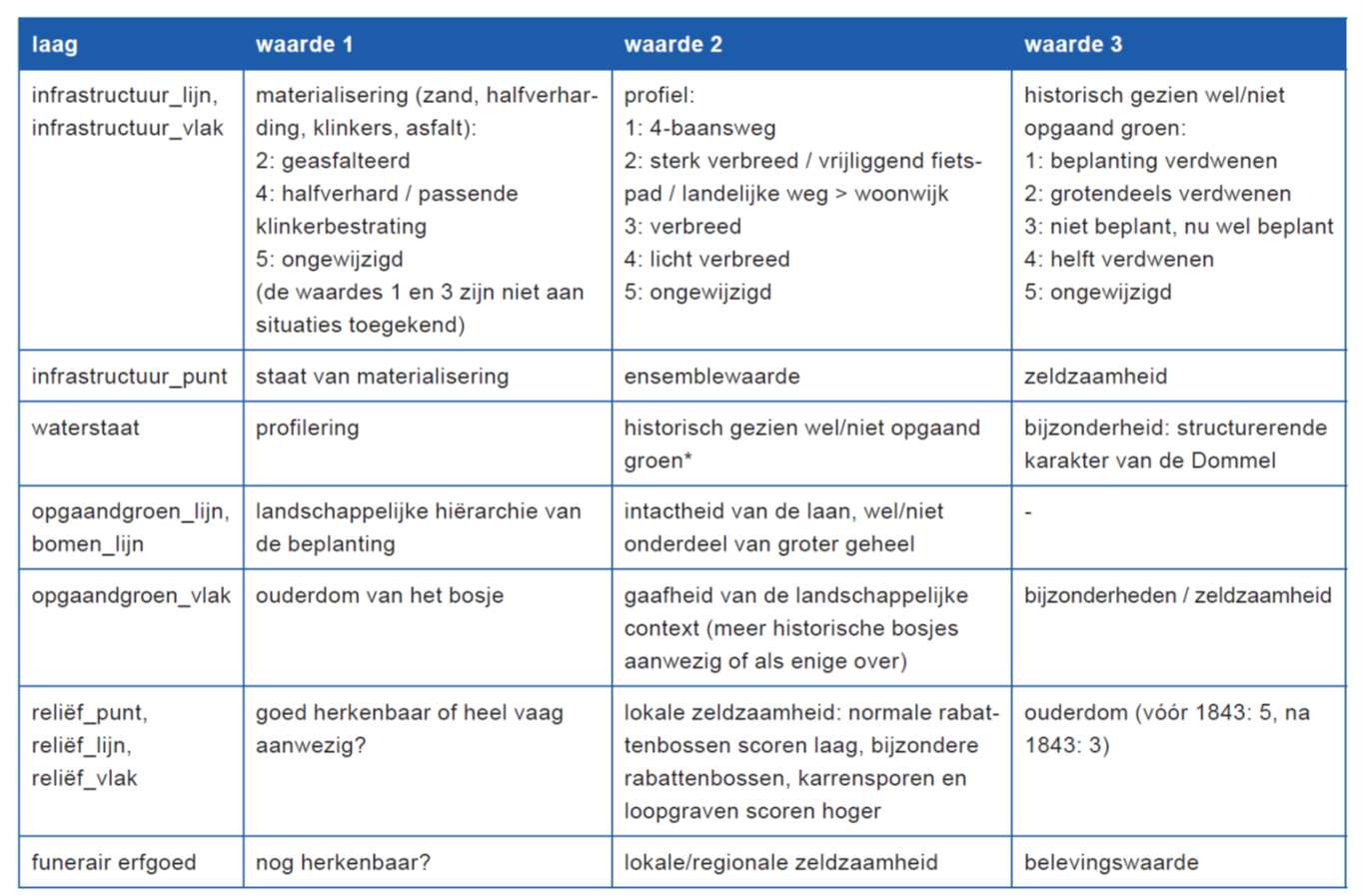 Value map of historical urban development and built heritage The value map of historical urban development and built heritage indicates the protected national - and municipal monuments, protected town and village views, municipal archaeological monuments, cultural-historically valuable objects, historically valuable works of art, historic roads and waterways, historic urban structures and valuable landscaped greenery and trees, which are important for the recognizability of the historical development of Eindhoven. Valuation To determine which areas and structures (in addition to those already protected) can be qualified as historically valuable, selection criteria have been used that are derived from the criteria that apply to monuments. These criteria are: 1. city-historical significance: as an expression of or source of knowledge for the historical development of the city in social, economic, administrative, religious or cultural terms; 2. architectural and/or urban significance: representative of a certain building style, building type or technique or as an expression of an urban development or architectural concept; 3. situational value: historical-spatial, structural, aesthetic and/or functional cohesion of geomorphology, allotment, buildings, road structure, public space, green elements and/or water; 4. authenticity: recognisability and/or intactness of the original characteristic. The rating is the result of a combination of criteria. A gradation was not chosen because the weight of the various criteria would then not be clear. For example, what has lost its integrity can still be important from a cultural-historical point of view. In the descriptions, a reference to these criteria indicates in what respect an area or structure is of cultural-historical value. The CHW map as a policy framework The cultural-historical value map is a policy framework that indicates where which cultural-historical values must be taken into account in development visions, zoning plans, plan development and restructuring and when formulating aesthetics criteria. The values described provide guidance for zoning plan regulations, amendments to zoning plans or the spatial substantiation of an environmental permit. Decision-making on area development, layout or restructuring will be partly based on a historical analysis and valuation. The results of this are processed in the area frameworks. The designation on the card therefore has an attention value. Development visions and spatial plans in which cultural-historical values are at stake require further analysis. The analysis functions as an impact report and the frameworks for area development or design of public space will indicate to what extent and in what way the described values can be incorporated and how certain characteristics will be dealt with. In expected archaeological areas, the zoning plan regulations will include the condition that development can only take place after archaeological research has been carried out. The costs of this should form part of the planning according to the principle “the disruptor pays”. In some cases, the presence of an archaeological monument may mean that it must be preserved and incorporated. Preservation of cultural-historical qualities will also have an effect on aesthetics supervision, because the described characteristics of the various areas will be adopted in the area-oriented aesthetics criteria. The cultural-historical value map is not a static document, but will be updated regularly. Values map historical cultural landscape manual The landscapes and settlements shown on the map can be divided into the following landscape types:
  following matters: infrastructure, water management, ascending greenery, religion and funerary heritage and relief. Value map of historical urban planning and built heritage The cultural-historical values are divided into various themes, which are shown as separate layers on the map (see legend). The areas are linked via a code letter and a serial number to a database of descriptions and images. This data can be called up on the digital map in GeoFundament. The map is divided into the following layers. - Urban structures (code letter S): this layer includes both the historic urban structure and the buildings related to historic roads. Protected town and village views designated under the Monuments Act can also be found here (code letter BS). In addition, the rivers, streams and canals are included. - Landscape and green structures (code letter L): this layer also includes agricultural settlements. - Archaeological Forecast Areas (code letter A): this layer contains the areas that appear on the Archaeological Forecast Map. The areas that have been surveyed, the areas that have not been surveyed and the archaeological monuments are marked differently. Apart from this dataset, the following can also be found on the portal: Monumental trees (can be filtered within https://data.eindhoven.nl/explore/dataset/trees/information/) and National and municipal monuments (see https://data .eindhoven.nl/explore/dataset/monuments/information/)
Data and Resources
-
jsonhttp://publications.europa.eu/resource/authority/file-type/JSON
No description of this distribution is available.
-
jsonhttp://publications.europa.eu/resource/authority/file-type/JSON
No description of this distribution is available.
-
csvhttp://publications.europa.eu/resource/authority/file-type/CSV
No description of this distribution is available.
-
geojsonhttp://publications.europa.eu/resource/authority/file-type/JSON
No description of this distribution is available.
-
shphttp://publications.europa.eu/resource/authority/file-type/SHP
No description of this distribution is available.
-
Cultuurhistorie - Schemahttp://publications.europa.eu/resource/authority/file-type/JSON
[{"name":"OBJECTID","code":"objectid","type":"int","description":null},{"name...
Additional Info
| Field | Value |
|---|---|
| Source | https://data.eindhoven.nl/explore/dataset/cultuurhistorie/ |
| Last Updated | August 3, 2023, 06:49 (UTC) |
| Created | July 13, 2023, 07:18 (UTC) |
| harvest_object_id | 2451ae1b-61bc-41a5-8223-d1644e7aa396 |
| harvest_source_id | 2d143cca-7932-40e0-9df7-9fe853be01b4 |
| harvest_source_title | OverheidNl |